
| HRLPC Home | Distance | Maintained By | Parking | Trail Walk | Canoe/Kayak |
|---|---|---|---|---|---|
| Trail Restrictions | Blaze Markings | Trail Benches | Trail Photos |
Maintained by: The Hockanum River Linear Park Committee (HRLPC)
Parking at the beginning of the trail:
Parking for the New State Trail is now located in the West End of the Cheney Technical High School, Student Parking Lot,
on Middle Turnpike West, Route 6 and 44, Manchester, CT.
The trail walk:
(Note that the HRLPC favors locating the trail as close to the river as possible when laying out and clearing trails.)
After parking along the west side of the lot you will see, at the trailhead,Ā a short set
of steps going down to a short grassy access path to the main Connecticut Light and Power (CL&P) driveway, coming in from
their gate from the road. (This driveway provides vehicular maintenance access to the major overhead power lines running
north and south over our hiking trails).
Follow this driveway to the right for maybe 50 feet, past River Bend Trail #1, which goes to the left to our Hockanum
River Dock for launching canoes and kayaks. Then, just beyond,Ātake the second left, River Bend Trail # 2, that goes through
wetland upstream, over 2 -Ā12' bridges over a littleĀpond and then a brook, curves around lots of Japanese Knotweed, along
aĀbackwater section of the River, more Knotweed, up a gradual slope, more curves and better views of theĀrapidly movingĀ
River and expansive marsh beyond, past a big Power Line tower, more River views, close under a large spring-flowering PinkĀ
Honeysuckle Bush and finally a bench with a great view of the Hockanum River and maybe a beaver swimming by, with luck.Ā
Sit hereĀto enjoy the vista upstream.
Then, going ahead again, close along there river, the trail goes through a Memorial Tree Planting area ofĀpast
Committee members White and Austrian Pines and bench for contemplation
Still further ahead the trail winds through deep forest and wetland, along the river, and then out to and over a 40
foot Bridge built by Boy Scouts in 2005, over a seasonal pond, then close upstream along the river again with another great
view of the waterway.
Beyond, the trail curves again through more mature forest then around to the right and out to another opening under the
Power Lines again, more beautiful grassy path and then reentering the woods under mature Viburnum, Spicebush and Red Twig
Dogwood shrubs and still another bench. Sit here awhile and enjoy the view of the rapidly moving river under a huge fallen
maple tree.
In the diagram below, click on the "Boat Launch" icon ![]() to jump to
the Town of Manchester's "Canoe & Kayak Access Guide" page, for information on this launch site.
to jump to
the Town of Manchester's "Canoe & Kayak Access Guide" page, for information on this launch site.
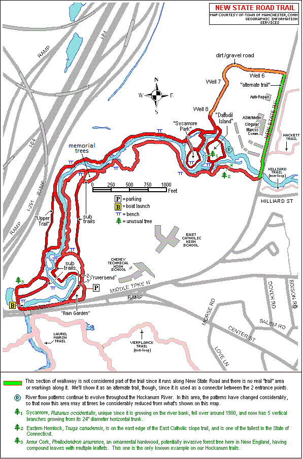
Then the trail curves, around to the right, again through more big forest trees, then curves left, upstream over
several boardwalks, comes out under a few large White Pine trees, curves left, over another boardwalk between 2 tranquil
Vernal pools, proceeds still upstream through more mature shrubs an finally comes out to a clearing and a big White Birch
and still another bench with a new vista of the Hockanum.
Now the path goes up a set of steps, along a narrow boardwalk, built into the side of an eroding slope, with the East
Catholic High School ball fields high above.
The trail, now narrow with a rope railing along the river side, curves along the slope, then makes a sharp right turn
and up a 12 foot ladder, with a wood railing for security.
Now higher and more winding, the path follows the eroding slope still upstream with lots of railings and steps along
the way, now down the slope gradually and finally out to a flat clearing and lots of big White Pines and hemlocks
everywhere.
There is an exiting path here, to the right and out to the East Catholic Ballfield nearby.
Staying on the main trail, the route to the left,Āfollows close to the river and still another bench, behind some
shrubs,Āwith another fantastic panorama of our famous three-way river intersection close at hand.
Going upstream again, the trail comes to a 35 foot footbridge, over the river onto Daffodil Island and follow the loop
trail, either to the right or left,Āaround theĀ4 acre island to the boardwalk and stepping stone course, exit off the
island, out onto the north side of the river.
The goal for Daffodil Island is to extend the Committee's planting of Daffodil bulbs each Spring.Ā To date we have a
cluster of daffodils around the bench on the southwest corner of the island, and each spring we plant to add a new bench at
another corner of the island and daffodil bulbs around it.
Now on the North side of the Island there is another bench facing a silted section of river, with no flow.Ā The trail
forks and the right branch takes apartment dwellers to the Riverview Apartments out on New State Road. The left fork goes
downstream, along the river, and bearing further left the path goes, over the river, on our 30 foot bridge onto Sycamore
Island and some very big Sycamore trees.
The trail makes a big loop around Sycamore Island past still another bench, and again facing the same three-way
junction of the River, and some spectacular Yellow Iris, at the river's edge,Āin Spring.
Going downstream further the path goes over another Committee footbridge with railing, then curves around to the right
and left and out to still another long footbridge off Sycamore island.
Here the left fork goes further downstream, close to the River and over more footbridges, the firstĀis theĀoriginal
modest bridge built by the Committee back in 1979.Ā
Following closely along the river still downstream the path passes another bench, more deep forest and then out into a
more open meadow, big Winterberry bushes with spectacular red berries in autumn, then lots of Knotweed, more tall shrubs
and over a very unique angulated footbridge.Ā
Beyond, the path, at the edge of the river,Āgoes by some tall indigo shrubs with bright purple flowers in mid-summer
and the most panoramic vistas of the river looking downstream.
Then aheadĀis a very tall set of 25 steps up to a tall ledge and more views of the river from high above.
Here the trail goes by I-84,Āoff toĀthe right, with big White Pines as a buffer, planted by the Committee 20 years ago.
Just beyond, the path splits, one going straight ahead, still on the ledge, and just ahead is the very unique bridge,
built by the Cheney Technical School Students IN THEIR SHOP and trucked here.
The path, going down the hill follows a steep set ofĀsteps,ĀgetsĀvery closeĀto the river, and is stillĀgoing downstream.
This lower trail follows the river in floodplain, past a big river-side Sycamore tree, out into an open meadow with
lots of Knotweed and 3 smaller sycamores, planted from seed many years ago.Ā The Spring Beauty flowers, in the middleĀof
the path,Āare unique here in early Spring.
Then theĀtrail goes over our Second Footbridge, built in 1983, upĀa fewĀsteps, hold the railing here,Āand joins the
upper trail, goes to the left andĀstill heads downstream and past another bench on a small knoll.
Continuing ahead the path curves around over a few more footbridges, with forest on the right and floodplain on the
left, often under water in the spring floods.
Then the path winds out to and along the chain link fence, overĀa series ofĀnarrow boardwalks, and tiny brook,Āand out
to Middle Turnpike West.
To get back to the trailhead,Ā hikers must go out on the pavement and turn left, watching out for traffic, stay close
to left side of the road and guard rail, cross the Hockanum River Vehicular Bridge, do not cross the road, andĀat the east end of the guard rail, turn left into the entrance of our Rain Garden Park, which we landscaped, in fall 2013,Āin memory of a recently deceased Committee member.
The path, now the CL&P driveway again goes to the access path to Cheney Tech and the parking lot.
Canoe/Kayak: Details on the boat launch icon can be found on the Town of Manchester web
site's